Impact Assessment - Results/Tools
<—Back to Ag Resilience Plan Summary
What are the major impacts to agricultural viability in our county and how are they projected to change in the future?
Below you will find tools created to assess risk on your farm regarding groundwater, saltwater intrusion, flood depth predictions, and climate impacts to crops. To read the full Impacts Assessment chapter, click here.
Flooding
Many factors are leading to changes in flooding for both the Snohomish and Stillaguamish Rivers. In some areas, these changes are already impacting farms. Bank erosion, flood debris removal, crop and soil damage, and drainage all create challenges.
Increases in the extent of flooding will put additional farmland at risk of inundation, particularly during more frequent storm events (such as the two-year and ten-year floods). Tens of thousands of additional acres will be flooded on a two-year event by mid-century and critical stage heights will be exceeded more frequently each year.
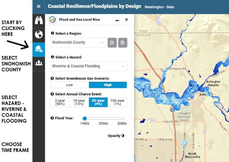
Find your location on the map to see what levels seas might rise within time frames or with various greenhouse gas scenarios. If you get stuck, click the image on the left for some basic instructions.
Groundwater
Increased flooding and rising sea levels are creating a “coastal squeeze” where farms near the river mouth are at risk of increasing drainage challenges, saltwater intrusion, and pressure on sea dikes. Groundwater modeling conducted by Cardno shows how this squeeze is projected to impact groundwater levels so farmers can plan for changes in drainage management.
Rising sea levels are anticipated to delay the time when farmers can access their fields in the spring by up to four weeks by the 2050s and up to five weeks by the 2080s. The combination of field work (monitoring wells) and modeling was used to create predictions.
Washington Sea Grant and University of Washington’s Impact Group released a sea-level rise report that provides the clearest picture yet of what projections may look like in Washington State. For more examples across the Marshland and Stillaguamish FCDs, click here.
Click on the image above for basic instructions to look up your own property.
Saltwater Intrusion
On Florence Island in the Lower Stillaguamish, patches of farmland already experience saltwater intrusion above crop tolerance thresholds, and those impacts are likely to increase in severity over the next 50 years.
Areas closest to the shoreline are at the highest risk of saltwater intrusion. Areas within 5,000 feet of the shoreline are especially vulnerable, and areas within 10,000 feet could also experience increases over time.
Increasing pumping on Florence Island is not recommended unless additional groundwater analysis negates the finding of this study, as pumping could result in increasing the amount of agricultural land impacted by salinity.
The map above follows the same instructions as noted above. You can select Snohomish County, Saltwater Intrusion and/or threshold limits, or just intrusion relative to where you reside.
Subsidence and Aggradation
The analysis of subsidence for both the Stillaguamish and the Snohomish floodplains showed little direct evidence for regional subsidence, and limits the calculation of localized subsidence to no more than 2.4 inches per decade if it is occurring at all.
The Stillaguamish River channel is aggrading near the mouth, and this trend is likely to continue into the future. The Lower Snohomish River is not aggrading, but upper reaches (from SR-9 Bridge to the Skykomish) show some aggradation.
Crop Impacts
Increasing air temperatures in summer months are projected to negatively impact some existing crops while at the same time providing opportunities for new types of agricultural production. This warming will result in a longer growing season but also an accelerated growing degree day accumulation, which can have a negative impact on yields. Models project a decrease in summer precipitation and an increase in winter precipitation.
Climate Visualization Tool
By the 2040s, Snohomish County is predicted to have similar growing conditions to Santa Cruz County, California, just south of San Jose. By the 2080s, conditions are expected to be most similar to Santa Barbara County, just north of Los Angeles.
Washington State University created an online tool that allows farmers to view climate projections for growing season length, frost risk, heat stress, and crop maturity timing for their specific location.
Key Findings
To understand the impacts of climate change on agricultural land in the Snohomish and Stillaguamish River floodplains, the Snohomish Conservation District initiated technical studies on flooding, groundwater levels, saltwater intrusion, land subsidence and aggradation, and crop impacts. This chapter summarizes key findings of these technical studies.
Brought to you by:


Funding provided by: National Estuary Program, NOAA, Stillaguamish River Lead Entity, Estuary and Salmon Restoration Program, and Floodplains by Design
