WHAT IS A WATERSHED?
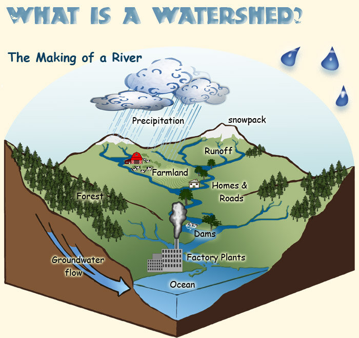
Image Credit. A. Vicente, U.S. Forest Service.
The term watershed describes an area of land that drains downslope to the lowest point. The water moves through a network of drainage pathways, both underground and on the surface. Generally, these pathways converge into streams and rivers, which become progressively larger as the water moves on downstream, eventually reaching an estuary and the ocean. Other terms used interchangeably with watershed include drainage basin or catchment basin.
Watersheds can be large or small. Every stream, tributary, or river has an associated watershed, and small watersheds join to become larger watersheds. It is relatively easy to delineate watersheds using a topographic map that shows stream channels. Watershed boundaries follow major ridgelines around channels and meet at the bottom, where water flows out of the watershed, a point commonly referred to as a stream or river.
The connectivity of the stream system is the primary reason for doing aquatic assessments at the watershed level. Connectivity refers to the physical connection between tributaries and the river, between surface water and groundwater, and between wetlands and water. Because water moves downstream, any activity that affects the water quality, quantity, or rate of movement at one location can affect locations downstream. For this reason, everyone living or working within a watershed needs to cooperate to ensure good watershed conditions.
This description of a watershed was taken from the Watershed Stewardship Education Program Training Guide, Oregon State University and Sea Grant Extension: http://seagrant.orst.edu/wsep
